We are neither in the amphitheatre, nor on the stage, but in the panoptic machine, invested by its effects of power, which we bring to ourselves since we are part of its mechanism. —Michel Foucault
Panorama/Panopticon
Portfolio is empty Upload Images

Panorama/Panopticon melds and layers image making technologies and viewing apparatus to depict a hyper-surveilled terrain and geography of division across time. The work employs tools and methodologies of cartography, reconnaissance and surveillance—including drone imagery, stereoviews, historic Cirkut camera photographs and 4K video.
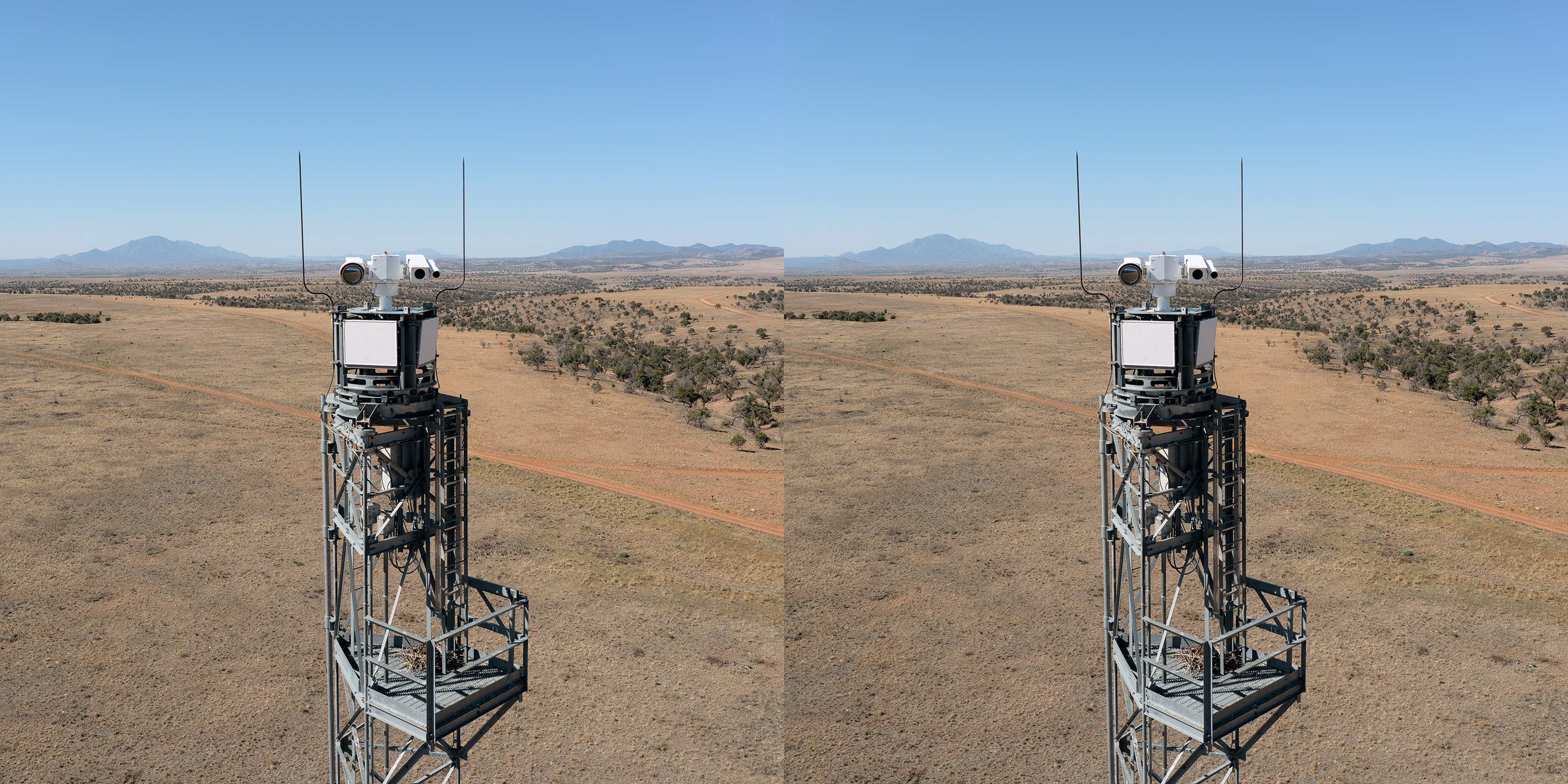
Focusing on the U.S.-Mexico border at the binational city of Nogales, and the adjacent 67 miles of international boundary between the Huachuca Mountains and the Coches Ridge, "Panorama/Panopticon" examines the proliferation of overlapping views and regulated spaces that have come to define the borderlands. Within a continuum of cityscape, rangeland and wilderness there are hundreds of cameras, motion sensors, laser rangefinders, radar arrays and transmission devices dedicated to the identification and control of human movement.
From a drone’s-eye view it is possible to discern both the density of surveillance apparatus and its limitations. The UAV functions as an analog for the system it records. If the nodes of viewing and sensing promise to deliver a comprehensive image, the UAV's counter view operates in the blind spots.
As an installation, “Panorama/Panopticon, Ambos Nogales” functions as a composite skyline of sorts. It incorporates an altered, historic 1910s Cirkut camera photograph showing an expansive northward view of Nogales in which the border is nearly illegible. In contrast, the contemporary southward looking UAV-made stereoviews, on the wall and ensconced in their stereoscopes, show a highly monitored and fortified border. The transformed cityscape of Ambos Nogales becomes a mirror for histories of separation, imperialism and colonial enterprise.
The two channel 4K video work, subtitled “67.4 miles,” documents a series of camera towers from both inward and outward looking vantage points. Audio is of refugees from Jalisco joined in communal prayer while awaiting transportation from a migrant aid camp and layered in opposition to Customs and Border Protection encrypted radio transmissions. Views inward and outward enmeshed with the contrasting signals of the borderlands, the frontier—from panorama to panopticon.
Notes on process
Stereoview imagery is made using a drone. The technique differs from conventional stereo photography which utilizes camera systems that have dual lenses which simultaneously expose image pairs that have sufficient parallax shift to create a stereo effect. Using the drone, pairs of images are made serially in order to generate the necessary offset for 3D viewing.
The viewing apparatus is a repurposed mirrored stereoscope of the type that were used for looking at aerial photographs as stereo pairs. Mirrored stereo scopes were a standard tool for both map making and reconnaissance work but have since been replaced by newer digital technology (photogrammetry and LIDAR). Mirrored stereo viewers are typically table top devices that require a user to look down at images. For this project, custom made armatures allow the viewers to be mounted on a tripod, while also supporting a stereoview image. The armatures were fabricated from artist designs using both manual and computer controlled machining equipment.
The panoramic image of Nogales, which depicts the binational city circa 1910s, was generated from a scan of an historic gelatin silver contact print. The original 8x48 inch image was made using Cirkut camera which pans as it makes an exposure. The telltale artifact of a Cirkut camera is the field curvature that is visible throughout the photograph—note the way that train cars recede spatially on the left and right hand ends of the image.
The file generated from the scan was digitally restored, upscaled and inverted to a negative using image processing software. The final print was then second surface mounted on acrylic creating a visual quality that echoes forward-looking infrared (FLIR) imaging technology which is widely used in border surveillance operations.

Panorama / Panopticon, 64.7 miles, 2024
Two channel 4k video with sound. Overall dimensions: 24x76x1"
i
PLAY SLIDESHOW
THUMBNAILS
Inquire about this Artwork